.png)

Have you ever felt truly lost? Not metaphorically – actually, physically disoriented. Wandering through the streets of a new city, circling the same corridor in a shopping centre, or trying to find the exit in a sprawling museum. Being lost is a universal human experience.
But why is it that some places are effortless to navigate, while others leave us turning in circles? The difference between these two experiences often lies in the fundamental spatial properties of the environment. Spatial analysis helps uncover the exact reasons certain places feel intuitive, while others confuse us.
In wayfinding this is important as we often cannot structurally change the built environment. Analysing the properties of spaces to determine where people will struggle to navigate enables us to identify the best locations for wayfinding interventions, such as signage, placemaking artwork, or where entrances or exits could be adjusted.

How spatial layout impacts navigation
The concept of ‘intelligibility’ is central to understanding how spatial layout influences navigation.
Intelligibility measures the degree to which local visual cues accurately predict wider spatial relationships. In an intelligible environment, what you can see from any given location provides reliable information about how that space connects to the broader system.
When this relationship is strong, people can navigate efficiently using environmental cues alone. This means that if you stand in one spot and look around, you can get a good idea of how the rest of the place is organised. In a well-designed city, looking down a street might reveal key landmarks or connections to major routes, helping you figure out how to get around.
Methods for analysing and quantifying spatial properties
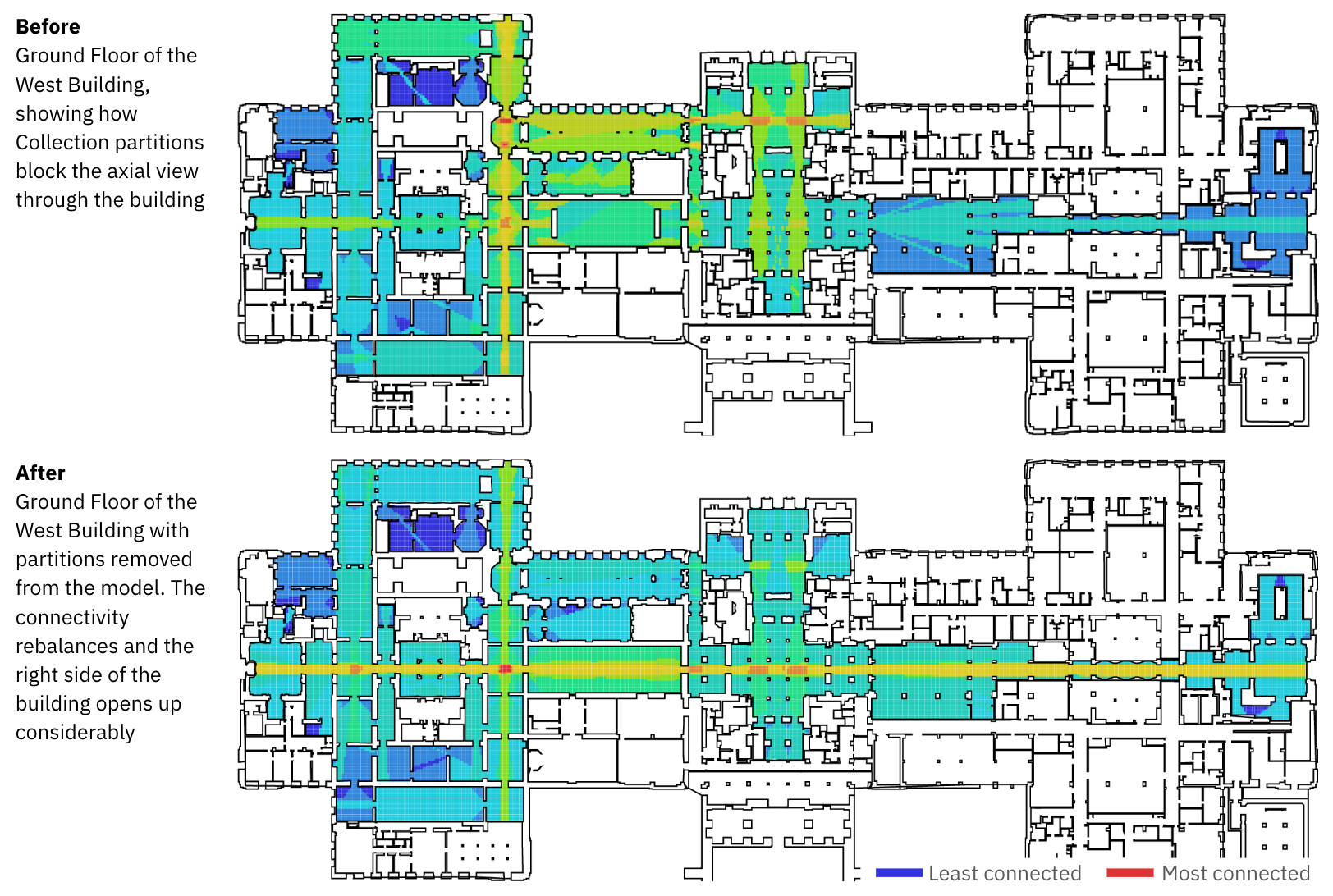
Space syntax analysis provides the practical tools to measure and quantify how intelligible a place actually is. By mapping out how different spaces connect to each other and analysing what people can see from various locations, this approach can predict whether the visual cues in an environment will help people understand the broader spatial system or will likely leave them confused and lost.
The analysis examines multiple layers:
- How easily accessible each area is from everywhere else.
- Which routes people are most likely to choose when moving from point A to point B. We often prefer to take routes with fewer turns over shorter distances, because turning requires more mental effort.
- Whether what people can see from key decision points matches the underlying spatial logic of the place.
When space syntax reveals low intelligibility (meaning the visual cues don’t align well with how spaces actually connect) it signals that people will struggle to navigate intuitively and will require more comprehensive wayfinding support. Conversely, highly intelligible environments often need minimal signage or interventions because the spatial layout itself communicates clearly.

Applying space syntax analysis to wayfinding design
For wayfinding design, space syntax is invaluable. It shows designers:
- Where the spatial logic breaks down and additional support is needed.
- Where natural sight lines can be enhanced to improve understanding.
- How to work with the inherent intelligibility of a place rather than fighting against confusing layouts with excessive signage.
Instead of compensating for confusing layouts with more signs, our starting point is to explore layout options that make navigation happen naturally. This could mean opening up sightlines between key destinations, clarifying the hierarchy of circulation routes, or strategically placing distinctive landmarks, such as environmental graphics or placemaking artwork, at decision points identified through integration analysis.
Signage placement benefits enormously from space syntax insights. Analysis can reveal the centrality of a space, or how potentially crowded a place will be. Areas of high centrality are good for placing signs with key orientation information, as they become natural decision points and ensure more people have the opportunity to see the information.
Digital wayfinding systems increasingly incorporate spatial analysis findings. Routing algorithms can consider not just simple distance, but also factors that impact how mentally or physically demanding different paths might be, assessing data on percentage incline and steps, or how many turns you need to make. Some systems will prioritise suggested route options having learnt to predict your preferences and movement habits.

When developing wayfinding systems, spatial analysis is enhanced by behavioural validation through user surveys, tracking studies and real-world observation. By comparing predictions with actual human movement, we can see where space syntax performs well, and where other influences, such as personal preferences, cultural context or prior experience, play a decisive role.
Creating environments that guide people naturally
Spatial analysis plays a significant role in creating intuitive, inclusive wayfinding. It provides us with interdisciplinary tools to measure how the environment and key elements shape people’s experience and decision-making. Prototyping and piloting then enable us to test these evidence-based design and planning choices with real-world human behaviour.
Incorporating these scientific methods into system development ensures places and infrastructure are set up to work in harmony with the way people perceive, think and move, meaning we can feel lost less often.
